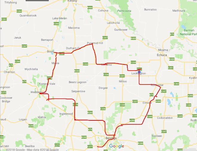
October cycle tour map

October cycle tour map

Pages

Sunday, March 28, 2010

Bayswater to Warburton


Bayswater to Warburton = 47km
Cummulative total = 47km

Just a quick ride before we head off north after Easter! Unfortunately we were meant to head off on Friday but we could not get a camping booking at Upper Yarra Dam over the weekend so instead we will head there tomorrow and stay until Wednesday and then make our way back to Warburton and onto Bayswater on Thursday in time to avoid the awful Easter rush!
We started out at around 9.30am and believe it or not (and I actually managed to get a photo of it to prove it!) but Dad was actually ready first and was (dare I say it) WAITING FOR NEIL AND I!!!!

He was all packed yesterday whereas I had to pack up the food bags and couldn't do that until this morning and Neil had a few bits and pieces to pack up and so Dad was ready well before us!
So it was an uneventful ride via the rail trail to Warburton. Neil and I both noticed that the Montrose hill on Canterbury road and the Mt Evelyn hill were alot easier to do ... in fact Neil says that it was easy but I think that is exaggerating a bit and more like it was rideable and we both didn't have to stop and walk and found that our legs were stronger to cope with it ... Dad thought that it was tough but at least he didn't nearly dye of a stroke like Neil did on the Montrose hill when he first did it and he also coped really well with the Mt Evelyn hill.
There were heaps of riders and walkers on the rail trail today and here at Warburton campground there are a few campers. At least there are more people here than last time - we were the only campers and it was freezing!
Kouta is incredibly excited about being on the road again and is loving the camping and has spent the afternoon bounding around the grounds acting like a puppy!
We are camped near the shelter (like last time) and you will see from the photo below our tent (yellow) and dads' tent (green) ... the area between the 2 tents is what I like to call the "snoring zone" which basically means that the distance has to be great so we don't hear dad snoring!!!!

When we got hear around 2.30pm it sort of began to rain not really heavy just a spinkle and at the moment now it is trying to rain, although rain has been forecasted we are not sure if Warburton will get any (you would think it would being up in the ranges!) but it is still pleasantly warm at the moment.
There were quite alot of campers still here at that time - I think they check out late in the afternoon especially if they only have to go back home in Melbourne somewhere.

The above photo is the shelter that has a fireplace and tables and as you can see we certainly do spread out and currently have 3 days worth of food with us - around 15kg to be precise! As up at Upper Yarra Dam there are no shops (even along the way) to pick up supplies so we bought most of it in Bayswater and a few bits and pieces at Yarra Junction.
I remember last time I was here I don't think I got a photo of the Yarra River that runs alongside the campground. It is so peaceful up here and it is a shame that anyone is here really!

Not too sure if I will get internet reception up at Upper Yarra Dam so there maybe no postings until Wednesday. Until then happy cycles

Thursday, March 25, 2010

check out my haircut!


Hey mum check out my hair cut ... it is a very unique style called "the I can't be bothered looking after my hair" style!!!!
Alot cooler under the helmet and it is not exactly a flattering photo as I had "helmet" hair when this was taken!

Wednesday, March 3, 2010

Winchelsea to Geelong


Winchelsea - Geelong = 44km
Cummulative total = 1144km
We woke this morning very early as the campground is right on the A1 and there were quite alot of noisy trucks going through at around 5.30am ... even though we woke up early doesn't mean we got out of bed to make an early start!
It was a cloudy but warm start at 8.30am and we decided to take a different route to Geelong instead of going through Inverleigh and Bannockburn. We rode 6km north on the Inverleigh road and then took a dirt road for 6km towards Gnarwarre. At first the dirt road was very sandy and soft but after a few 100ms' there were more harder sections on the road to ride on. Very few card used this road and there was one who couldn't believe that he saw bikes on the road that he had to stop and pull over and chat to us. I think he drives this road quite often and was very surprised to see us on it. After the dirt road we turned east onto a sealed road to Gnarwarre. It was undulating up and down to get to Gnarwarre but the road was fairly quiet for us. At Gnarwarre we had a very early cuppa at the CFA sheds.

Nearly every small locality has a CFA shed and they come in very handy for us to rest the bikes on!
From here the road continues east towards Geelong and is very undulating (but rideable!). Just before Ceres the road goes down a bit and I tell you there are some real "nuff nuffs" out there when it comes to driving - 2 in a space of a down hill! One old guy decides to overtake Neil on a blind curve and I am well ahead and can see him in my rear vision mirror and point to the other side of the road indicating that there is another car coming the opposite way but he stupidly stays out half on the other side of the road between Neil and I and the car coming the opposite way has to move over. At the bottom of this hill I am far ahead of Neil and another car overtakes me clearly seeing there is another car coming the other way but still overtakes and the car coming the opposite way has to get off the road! what is it with overtaking people on bikes are people just dumb?
We turned North just before Ceres and cross the Barwon River - plenty of water but it is not really flowing (stagnant).

We took a small break near the river - it is a lovely spot! Just a bit further up the road we pass a farm and at the corner of my eye (we both saw it!) I saw a huge bird and neil yells out that it is a wedged tail eagle. Now we are not too sure if it is a wedge tail eagle and we will check when we get back to Melbourne in the bird book, but it was HUGE! I thought they were only in the outback as we use to see them flying in the sky all the time. But this one was being harassed by 2 small birds on a farm and I have never seen one that close and I couldn't believe just how big it was!
As we were circumnavigating our way around Geelong I guessed we were probably around 10km out and we climbed a medium size crest and at the top was a farm that had these boulders. I suppose you are wondering why we took a photo of them .. well around this area if there is stones they tend to be the grey ones used on fences like at stoneyford but these were like smooth boulders - almost like the devils marbles!

So Neil stopped half way up to take a photo of them while I continued climbing to the top to get a photo of him and the area we just cycled through and I also loved the fact that around these boulders was this one little tree!


Neil and I must have been thinking the same thing - he takes a photo of me while I am taking a photo of him!

Not long after this we get to the main highway and have to ride around 4km on it (and it was the worst 4km of the day!) and I had time to reflect and so did Neil as we both came to the same conclusion that it must be "3rd time lucky" the first time we were here we had 50km per hour winds (headwind) the second time we had a heat wave and third time was just right!
Tomorrow we will be heading for home!

Tuesday, March 2, 2010

Colac to Winchelsea


Colac - Winchelsea = 61km
Cummulative total = 1100km
You know how Neil and I dislike going on any major highways ... well today had to be the record for kms' done to avoid the main highway! Normally it is 37km to Winchelsea from Colac but if you look at our map you will see that we decided to cycle the north roads (as we have previously cycled the south roads through Birregurra etc and decided we would like a different view!). It really is the loooooooooooooong way around to Winchelsea - 61km to be precise! Crazy aren't we!
It was a lovely road and the scenery is different too. Alot flatter and not so hilly like the Southern roads, but in saying that you are also exposed to any wind that might be whipping around! And believe me the wind was blowing from the South East so the final 30km was straight into the wind and I tell you at 10km out of Winchelsea I was just about over the fact that Winchelsea was still toooooo far away! And at that point I did think that we had made a mistake choosing this road with the final 30km into the headwind (the first 30km we had a tail/cross wind) as it just dragged on and on and on and on and you always hoped that over the next crest or just past the line of trees you would see Winchelsea ... but no the road just kept going!
But like I said the scenery was nice and not long into the morning we came across this bluestone farm house and outside were 3 alpacas (at least I think they are!).

They were incredibly interested in either Kouta, us, the bikes or all of us including the bikes! As they ran to the fence and were staring at us with such curiousity! They looked very cuddly and would make a lovely pet in winter!

Even Kouta was interested in them!

I liked the black one!
Also along the way we saw heaps of bulls out in the fields and there was one paddock that had these huge bulls and no amount mooing and noises from us could stir them to start running, not like other cows and smaller bulls which love it when we moo at them!
Not long after our cuppa break we came across this field of Sunflowers, we were not sure why the field had sunflowers in it but it was like they were deliberately there as they were growing close together like someone is growing them as a crop. Maybe they grow them to fertilise and nourish the field?

Mt Gellibrand is in the background - last time Neil and I saw sunflower fields was when we were in Montana and there were heaps of fields there!
We got to Winchelsea around 1.30pm and the caretaker Geoff and his little dog Fred were happy to see us.
Tomorrow we move on to Geelong and will take a different road from last time - just so we can mix it up a bit. I will have to look at the map and check which way the wind is blowing tomorrow as I don't particularly want to have the last part into a headwind (I don't mind it first thing when I have fresh legs!)