

SEYMOUR TO ALEXANDRA = 85km (via Goulburn River High Country Rail Trail - GRHCRT)
ALEXANDRA SHOWGROUNDS = $25 (powered)
It has been a long and very hard day - all 3 of us are very exhausted. It took us over 6 and 1/2 hours to ride the 85km of which 75km was on the Rail Trail.
My day didn't exactly start great as I woke around 2am with hayfever and didn't really get back to sleep until after 4am only to wake again at 5.30am. So we got up early and was out of the park around 7.15am. We rode along the Hume for the first 10km and then took the Tallarook turnoff. Like with most Rail Trails here in Victoria the start is exceptionally hard to find in a town, for some strange reason the rail trail developers tend to think the only people who will use is will be locals and therefore don't need to put up any signposts anywhere except for some vague street signs pointing in the general direction. We finally found a rather miserable looking starting sign ...

There a nice introduction to the rail trail and
you have a quick short climb out of Tallarook and then a nice down hill to the
valley floor. Heaps of monarch butterflies
flutter around you as you ride along as they are sitting along the edge of the
path on all the leaf litter … I nearly had to put my fly net on and call it a
butterfly net as they kept banging into the face – they are far more pleasant
compared to flies!


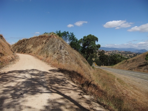
Great scenery along this trail ...


the hill climb from Yea up to Cheviot tunnel (9km from Yea)


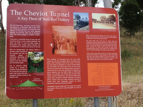

looking back in inside the tunnel which is about 201m long

after the tunnel it is down hill to Molesworth - again the scenery is spectacular

the Goulboun River

This is the 2nd main climb for the day from the Alexandra turnoff and goes for just over 9km - the road you follow is the one on the right while the rail trail is the track on the left
On the way down the Alexandra hill you can see the hills in the distance that we will climb over tomorrow

In case I forget my notes on the trail here are just some of the important ones for you Dad:
Start at Tallarook 0km
@ 6.4km shelter, no toilet, 50m from
river (over the fence), okay to camp but next to quiet road.
@7.7km toilet with rainwater, next to
road, okay to camp
@ 13.7km Granite siding and Trawool
Resort – toilet with rainwater, not good to camp, from here to Kerrisdale it is
quite undulating and steep in places as they don’t necessarily follow the
original train line. From Granite to
Kerrisdale the trail is undulating.
@ 17.7km shelter with table, okay for camping,
close to road
@ 19.6km Kerrisdale siding – toilet with
rainwater, not good for camping. From
Kerrisdale to Yea the trail flattens out a bit.
@ 32.7km Homewood siding – toilet with
rainwater, close to road, okay to camp, from here to Yea it is a gentle down
hill and what they would describe as black gravel sealed trail
@ 38km Yea township – follow rail trail
signs to a park and it begins again on the opposite side past the siding and
shed, from here there is a gentle 9km hill to Cheviot tunnel
@ 44km toilet with rainwater, okay to
camp under pine tree, farm sheds nearby
@ 46km Cheviot siding – table and
shelter, nice view
@ 47km Cheviot tunnel, this is the top
of the hill and from here it is 8km to Molesworth of which 5km is down while
the remaining 3 is along and down a bit – despite only having 5km of down hill
the remaining 3km has some steep declines as they don’t follow the original
train line
@ 55.5km Molesworth siding – toilet with
rainwater, okay to camp
@ 60.1km Cathkin siding – toilet with
rainwater, not great for camping
@ 60.5km the turnoff for Alexandra, this
track for just over 9km (the hill part) is black gravel sealed trail which
starts off okay and towards the top can get quite rough.
@ 69.8km top of the hill and trail
changes to lilydale topping
@ 72.5 bottom of hill, small climb for
about 1km and then down into Alexandra
@ 84.2km end of railtrail – town center
is a further 1.2km on.
Overall – the rail trail sure beats
going along the busy road (especially on the weekends). We came across some riders at various places –
some were weekend touring, some where groups out riding and some where
families.
There is not a lot of storm damage but
at times there was some deep bike wheel ruts and lots of them of which they are
now dry so your wheel sometimes slipped into the ruts.
Like all towns, at Yea, it can be easy
to loose the trail, you end up at the park with numerous tracks going
everywhere but up and with the siding and some sheds, the trail restarts at the
opposite end of the park from where you enter it.
The trail has markers every 5km. Only one mistake on the official rail trail
brochure – it states toilets at Trawool – but there isn’t they are at Granite
which is just 2km further on. Trawool is
just a siding nothing else.

No comments:
Post a Comment